Possibilities and limits of the archeogenetical analysis on the ancient human remains
B. G. Mende
Archaeological Institute of the HAS
Uri u. 49, 1014, Budapest - Hungary
Tel. +39 3759011 508 - Fax: +39 224 6719
E-mail address: mende@archeo.mta.hu
The archaeogenetical investigations – parallel to the wide spread of molecular genetics – have a growing importance in archaeology and population history. This positive change in playing a role in historical research is based partly on the technological development of the last two decades and partly on the recognition of the fundamental conservatism of the DNA.
The field was open for a multi-respect analysis of the DNA of several thousand years old human remains. The polimorphism of the DNA, especially on certain sections of the mitocondrial DNA, offered the possibility of the most thorough examination ever in relation to the spread and genetic variability of human species. Because of the fragmentary character of the survived ancient DNA sections, the morphometric features of the human skeleton and the genetic haplo-groups formed by the DNA-based polimorphism cannot be correlated. In fortunate cases, the archaeogenetic investigations make it possible to study illnesses of genetic origin, or to analyse the kinship in smaller groups of burials. The examination of the patrilinear and the autosomatic inheritance can be a great help in answering the major questions of the population history of the Carpathian basin.
The most recent investigations concentrate on the archaeological and historical preconceptions of the eighth-twelfth centuries, particularly on the problem of population and nation. However, the most distinguished results can be expected in relation to the population problems of the neolithic age. The archaeogenetic laboratory in the Archaeological Institute of the Hungarian Academy of Sciences was established to answer these questions.
The long-range financing of such investigations is, however, not solved properly, not least, because of the time needed and the hardness one has to face when trying to give an interdisciplinary interpretation. In favour of a modern human DNA contamination-free analysis, the recent tendency is to limit the number of research groups in order to focus the limited resources – among them the available grants and funds – in the major archaeogenetic research centres.
Laser Technologies in Cultural Heritage Conservation
Renzo Salimbeni
Institute of Applied Physics “Nello Carrara” Firenze
Via Via Madonna del Piano – 50019, Firenze - Italy
Tel. +39 055 5225312 – Fax +39 055 5225305
E-mail address: r.salimbeni@ifac.cnr.it
The state of the art of laser techniques employed in conservation of cultural heritage is continuously growing in Europe. After more than thirty years since the first experiment in Venice many advancements were achieved and now laser techniques are widely recognised as one of the most important innovation introduced, in the last decades, in conservation of artworks for diagnostics, restoration and monitoring. Many research projects organised at the European level have contributed to this achievement, being complementary to the development carried out at national level.
IFAC-CNR has carried out research projects on these topics, developing new laser instruments dedicated to the cleaning of deteriorated stones and metals. The laser systems have been validated after a vast experimentation, confirming a well controlled ablation of the deteriorated layers, while preserving the historical layers such as patinas or gilding. A number of case studies have validated these instruments on masterpieces of the Florentine renaissance and on archaeological pieces. IFAC is carrying out projects of research, of technology transfer and of international cooperation.
A very important role was played by the COST Action G7 “Artworks Conservation by Laser” for the decisive acceptance of these techniques. This is a networks of forty organisations, research institutes, conservation institutes, archaeology experts, museums etc. COST G7 has contributed a lot by exchanging experiences, comparing results, selecting best practices. After the COST G7 activity it appears now clear an evolution of the systems, a specialization of the cleaning task, the achievement of side-effect free procedures.
The validation of these advanced cleaning techniques has been extensive and diffused in many European countries. Laser-based diagnostics have also specialised their tasks toward material analysis, defects detection and multidimensional documentation. Laser and optical methods successfully monitor deterioration effects. In many European countries interdisciplinary networks are managing the experimentation of these techniques giving them a sound scientific approach, but also a technology transfer to end-users. So doing the appreciation for these techniques is growing in all the conservation institutions involved at national level, disseminating a positive evaluation about the benefits provided by laser in conservation. Nowadays laser cleaning is considered the most precise method available for the restoration intervention, in order to remove in a controlled way the degraded layers. Several laser systems became products for the activity of professional restorers and their increasing sales demonstrate a growing utilisation throughout all Europe.
The use of 3D technologies to survey and document archaeological buildings and sites
Belényesi Károly-Virágos Gábor
Archeosztráda Kft.
1119 Budapest – Etele ut 59-61, Hungary
Tel. +36 1 2253361 - Fax +36 1 2253362
E-mail address: archeo@archeosztrada.axelero.net
The laser technology doubtless represents the new generation of 3D documentation technologies. We cannot talk about experimental methods any more. Based on the surveys executed on sites – now also in Hungary – it is clear that the fundamental phase of the technical innovation arrived to its end. The research method is fast and provides spectacular results: there are only few specialists in heritage management, who are not convinced by the first insight. Still, the expected growing in the numbers of the surveys is late. Today, both the developers and the users are looking for a market, but they often have to face uninspected difficulties.
The antipathy or aversion, which hinders the wide spread of this new documentation technology, is based on simple, but real reasons. The infrastructure of the traditional manual system is very strong, it obviously tries to withstand any of the new methods, which intend – or at least seems to intend – to change fundamentally the practise, organisation, or system of it. Therefore, accepting the new methodology is not simply a matter of fulfilling a technological prerequisite. The major question is, whether a new attitude will emerge from the side of the heritage people to accept a new approach, a brand new way of thinking: do we want to and will we be able to apply, use, and exploit that surplus value, which is offered by the use of 3D laser technologies.
“Fast Archaeology”: Applying New Technologies in the Archaeological Research in the Civilian City of Aquincum
P. Zsidi – O. T. Láng
BTM Aquincum Museum
H-1031 Budapest, Záhony u. 4 - Hungary
E-mail addresses: h8692zsi@ella.hu; lang.orsolya@iif.hu
The growing number of investments in archaeologically protected areas mean greater challenge for archaeologists all over in Hungary.
It is especially true in the case of Budapest, where building activities bring to light the ruins of Óbuda, Buda and Pest. The primary intention of investors, even if they are interested in archaeology, is to have the excavation done by the Museum as soon and as cheap as possible. The demand is similar when constructing public utilities or in case of public transport. Museums can only adapt themselves to these demands if they apply new techologies in documentation and survey.
The Budapest Historical Musem has long been trying to apply these technologies. Photogrammetry, geophisical survey and laser-scanning were sometimes used as completing traditional documentation.
Testing these new technologies in reality has first been carried out this year. The reconstruction of the railway-line of the Szentendrei HÉV required special attention as it crosses the Civil Town of Aquincum. Comparing the plans of the transport company (BKV Rt.) to our informations of previous excavations, it became clear that the reconstruction could affect roman layers. The strictly built up project only allowed 16 hours for archaeological work to be done.
Taking up the tracks meant that a circa 400 m long and 10 m wide stripe of the roman settlement came more or less to light. The first step was the geophisical survey, which revealed walls of buildings of different orientations. Following the survey, cleaning of the surface was done when remains of buildings of unknown purpose came to light together with traces of terrazzo and heating channels. The documentation of this building together with other wall-fragments was carried out by laser-scanning during the night and also in rain.
This type of documentation carried out in a few hours, not only helped the archaeological research, but also resulted new informations: so far undefined data, deriving from previous years excavations in the Civil Town of Aquincum, could be explained and we can complete the topographical-chronological picture of the roman town.
Non-invasive instrumentation for diagnostics and colour control
Mauro Bacci
Applied Physics Institute “Nello Carrara” (IFAC-CNR), Firenze
Via Panciatichi 64 – 50127, Firenze - Italy
Tel. +39 055 4235217 - Fax +39 055 4235355
E-mail address: m.bacci@ifac.cnr.it
The fact that every work of art is a unique piece emphasises the necessity of working with non-invasive methodologies.
In this communication instruments, which were realized at IFAC-CNR, Florence, and their application to actual cases will be presented. Such instrumentation is based on spectroscopic techniques, namely image spectroscopy (IS) and fibre optic reflectance spectroscopy (FORS). Indeed, the integrated use of both techniques constitutes a powerful tool for obtaining a large amount of spectroscopic information without any sampling, thus overcoming all the limitations and problems involved in sampling operations. Moreover, the availability of lightweight and compact equipment makes it possible to perform measurements in situ on objects that cannot be removed from their location.
Furthermore, due to the fact that these techniques are non-invasive and are thus safe for works of art it is possible to re-measure the same object after a given time, to monitor the conservation conditions of the work of art, and also to follow the restoration processes. The methodology also enables the acquisition of a large number of spectra over the entire artefact. This wide sampling operation, the performance of which would be unthinkable with micro-sampling techniques, provides a large amount of data, which can be used for statistical analyses.
As regards the application to actual cases, two case studies will be reported: a) a Leonardo da Vinci’s painting, where pigments, binding medium, preparatory layer and previous restoration works were identified; b) the colour evolution of a Luca Signorelli’s predella was monitored over the years during the exhibition to the public, during the restoration intervention and after the restoration.
Finally, a brief account of the studies performed at IFAC – CNR about indoor light control will be given and the possible use of a new light dosimeter will be suggested.
River archaeology – a new field of research
Dr. Attila J. Tóth
National Office of Cultural Heritage
1014 – Budapest, Táncsics Mihály utca 1 - Hungary
Tel. +36 225-4820
E-mail address: attila.toth@koh.hu
The beginning of underwater archaeology goes back to the turn of the 19th-20th c. With the diffusion of autonomous diving equipment and the work of pioneers (such as J.-Y. Cousteau, G. Bass) underwater archaeology became a real scientific discipline. However these researches concentrated on marine archaeology. Even nowadays underwater archaeology means marine archaeology for most colleagues.
Systematic underwater survey of rivers began in France in the 60’s, but only in a small scale (L. Bonnamour in the Saone River). The physical conditions of the rivers are different from the seas: the visibility is close to zero, the current is strong, and the depth is only a few meters. It means that the methods and technologies of marine archaeology are not applicable automatically.
From the 90’s the Departement des Recherches Subaquatiques et Sous-marins began the large scale surveys of the French rivers. The National Office of Cultural Heritage of Hungary organised an underwater archaeological research programme in 2002. In 2004 the European Fluvial Heritage programme began with Hungarian, French and Slovenian cooperation. The aim of the programme was to exchange methods, information and experiences. This presentation summarizes the technologies used in underwater archaeological survey, their possibilities and problems.
The use of aerial photos and satellite technologies is diffused in archaeology. In river archaeology they are useful to detect ancient river-beds, roads and bridges/ferries.
Bathymetric survey is a combination of GPS, depth measuring and cartography. The isometric mapping of the river bed could help to find shallows (used often for crossing the river), artificial moles, and dams. This technology is easy and not expensive. Though it is not able to detect shipwrecks or smaller structures.
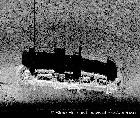
Sonar systems are often used in marine environment. Marine sonar is not able to make images in shallow water. The new high resolution side-scan sonar (900-1200 MHz) makes good images in rivers. The problem of using this technology is that in the case of underwater vegetation-cover or intense sedimentation (tree-chunks) it is not possible to see the river bottom.
The seismic radar penetrates into the sediments, detecting covered structures. This tool could also create isometric or 3D image of the river-bed. According to our experience this is the most useful technology in instrumental survey. Both of the mentioned technologies require underwater survey to identify sites.
In case of underwater survey and excavation the main problem is the orientation, the positioning of the site and the finds. The modern documentation tools of the archaeological research: GPS, laser technologies are not applicable under water. We can only apply hand measuring, but the scarce visibility makes it very slow and difficult process. The next challenge of underwater archaeology developers is to resolve the problems of underwater documentation.