River archaeology – a new field of research
Dr. Attila J. Tóth
National Office of Cultural Heritage
1014 – Budapest, Táncsics Mihály utca 1 - Hungary
Tel. +36 225-4820
E-mail address: attila.toth@koh.hu
The beginning of underwater archaeology goes back to the turn of the 19th-20th c. With the diffusion of autonomous diving equipment and the work of pioneers (such as J.-Y. Cousteau, G. Bass) underwater archaeology became a real scientific discipline. However these researches concentrated on marine archaeology. Even nowadays underwater archaeology means marine archaeology for most colleagues.
Systematic underwater survey of rivers began in France in the 60’s, but only in a small scale (L. Bonnamour in the Saone River). The physical conditions of the rivers are different from the seas: the visibility is close to zero, the current is strong, and the depth is only a few meters. It means that the methods and technologies of marine archaeology are not applicable automatically.
From the 90’s the Departement des Recherches Subaquatiques et Sous-marins began the large scale surveys of the French rivers. The National Office of Cultural Heritage of Hungary organised an underwater archaeological research programme in 2002. In 2004 the European Fluvial Heritage programme began with Hungarian, French and Slovenian cooperation. The aim of the programme was to exchange methods, information and experiences. This presentation summarizes the technologies used in underwater archaeological survey, their possibilities and problems.
The use of aerial photos and satellite technologies is diffused in archaeology. In river archaeology they are useful to detect ancient river-beds, roads and bridges/ferries.
Bathymetric survey is a combination of GPS, depth measuring and cartography. The isometric mapping of the river bed could help to find shallows (used often for crossing the river), artificial moles, and dams. This technology is easy and not expensive. Though it is not able to detect shipwrecks or smaller structures.
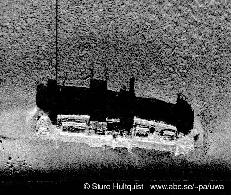
Sonar systems are often used in marine environment. Marine sonar is not able to make images in shallow water. The new high resolution side-scan sonar (900-1200 MHz) makes good images in rivers. The problem of using this technology is that in the case of underwater vegetation-cover or intense sedimentation (tree-chunks) it is not possible to see the river bottom.
The seismic radar penetrates into the sediments, detecting covered structures. This tool could also create isometric or 3D image of the river-bed. According to our experience this is the most useful technology in instrumental survey. Both of the mentioned technologies require underwater survey to identify sites.
In case of underwater survey and excavation the main problem is the orientation, the positioning of the site and the finds. The modern documentation tools of the archaeological research: GPS, laser technologies are not applicable under water. We can only apply hand measuring, but the scarce visibility makes it very slow and difficult process. The next challenge of underwater archaeology developers is to resolve the problems of underwater documentation.